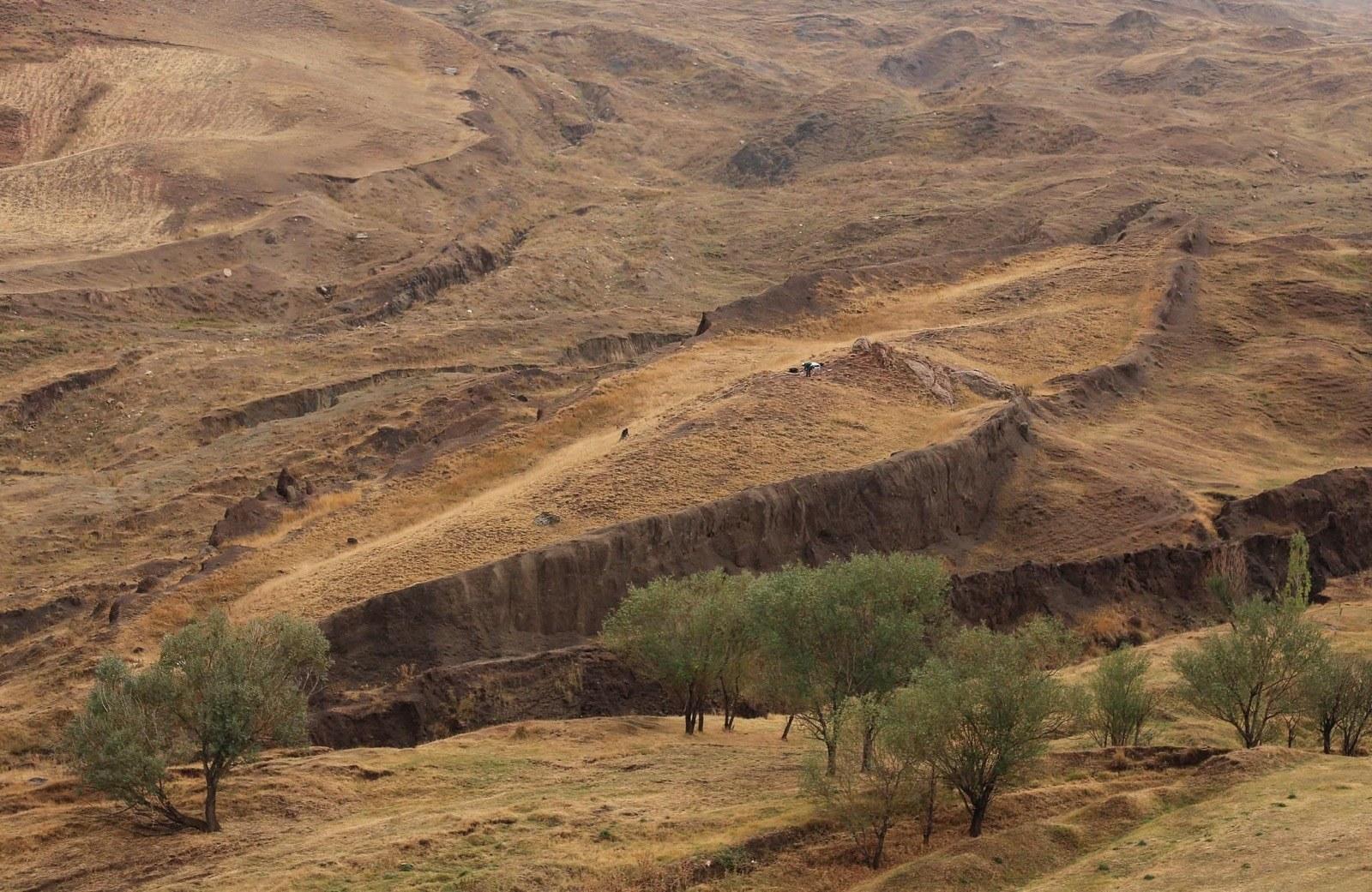
The 515-foot (157 m) Durupınar boat-shaped formation 19 miles south Mount Ararat, eastern Turkey.
IRVINE, Calif. and DOĞUBAYAZIT, Turkey, Aug. 18, 2026 (GLOBE NEWSWIRE) -- For decades, skeptics have had one simple answer for the boat-shaped Durupınar Formation: it is just a solid lump of natural rock. Last week, that answer got harder to defend. By bringing a highly specialized subsurface radar system – originally forged through cutting-edge U.S. Air Force defense research—to one of the world’s most famous proposed Noah’s Ark sites, the research team is completely upending conventional expectations.
Bakhtar Research and Engineering, LLC, and Noah’s Ark Scans have completed the first deployment of BakhtarRadar — a specialized subsurface imaging system originally developed as the U.S. Air Force EarthRadar — across the 157-meter (515-foot) formation near Mount Ararat. Leading the survey was Dr. Khosrow Bakhtar, ARSM, PE, Ph.D., a scientist who has spent four decades building detection technology for the U.S. Air Force, Navy, Defense Threat Reduction Agency and NORAD-USNORTHCOM. He was joined on site by Noah’s Ark Scans founder Andrew Jones, an independent researcher and software developer with more than 20 years of technical site investigation.
The mission was direct: put the “solid rock” explanation to the test. Is the formation a single homogeneous mass of natural stone? Does it contain internal structures? Where does the true bedrock lie beneath it — and how does that bedrock continue across the surrounding valley?
The preliminary answers are striking:
- The radar data do not show the formation as a simple, homogeneous mass of rock.
- Multiple strong subsurface anomalies and layering are being detected beneath the boat-shaped surface.
- In the deeper data processed so far, no clear bedrock boundary has yet been identified beneath the formation — the radar is looking well below where a shallow rock core would be expected to appear.
These observations are preliminary and remain subject to full processing and interpretation. But they strike directly at the geological objection that has been raised against the site for years — that Durupınar is nothing more than a natural pile of rock or mud draped over shallow bedrock — and they are already defining the top targets for the next phase: core drilling.
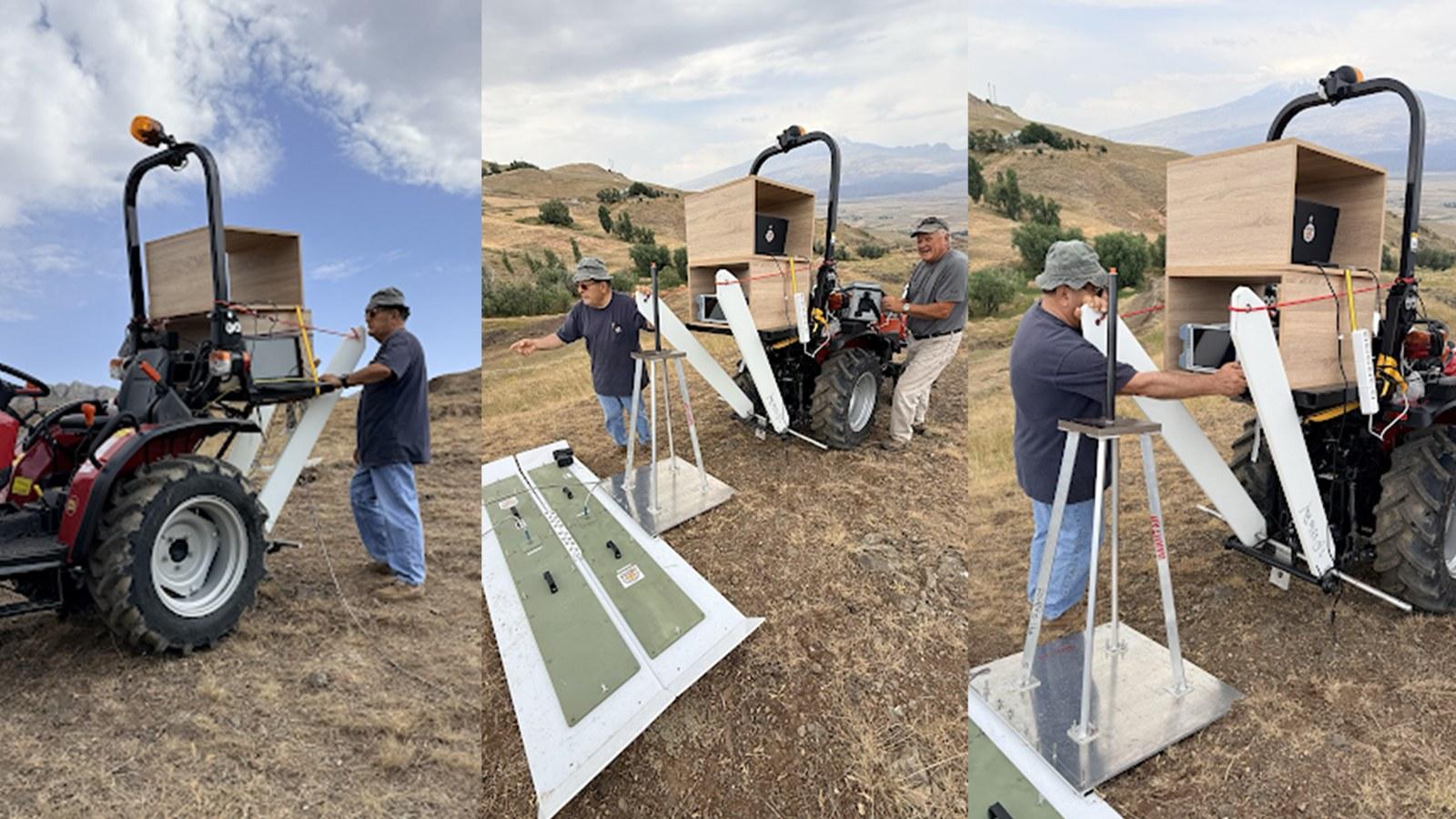
Photo: Dr. Bakhtar deploying his specialized radar on site at the Durupınar Formation.
“We believe the Durupınar Formation is the remains of Noah’s Ark, and that is exactly why we want to put it through the strongest scientific testing we can,” said Andrew Jones, founder of Noah’s Ark Scans. “One of the biggest questions has always been whether this is simply a solid natural rock formation. In the data we have reviewed so far, we are not seeing a simple homogeneous solid-rock signature. We are seeing strong anomalies and layers, and in the deeper data processed to date, we have not yet seen a clear bedrock boundary beneath the formation. That is extremely interesting, but we are still processing the data, and the next step is to use the results to put core drills into the right locations and test what is actually there.”
From Cartel Tunnels to the Durupınar Site: Dr. Khosrow Bakhtar - Four Decades at the Leading Edge of U.S. Defense Research
Dr. Bakhtar is not a conventional geophysical contractor. His career has centered on one hard problem: finding and characterizing what cannot be seen from the surface — buried objects, tunnels, cavities, shielded materials and complex underground structures. As Program Manager and Principal Investigator on more than 25 major U.S. Department of Defense projects, he has authored or co-authored over 200 technical papers and reports, and holds a Ph.D. in Engineering/Rock Mechanics with training at Imperial College London, Penn State, Princeton, UC Berkeley and the University of Utah.
BakhtarRadar was developed through U.S. Air Force SBIR Phases I, II and III as a near-field, multi-station platform for high-resolution, three-dimensional volumetric imaging of buried objects, unexploded ordnance, structures and voids — all at extremely low power. In demonstrations directed by NORAD-USNORTHCOM J42 at Otay Mesa and Calexico, the system detected and produced 3-D reconstructions of clandestine tunnels beneath the U.S.–Mexico border. His companion Forced-Resonance Imaging (FRI) technology, operating below 10 milliwatts — less than a cell phone — sharpens the detection of anomalies inside complex ground. That is precisely the challenge at Durupınar: separating layers, structures and discontinuities in difficult conditions and building a 3-D picture of what lies underneath.
In regard to the Noah’s Ark study at the Durupinar site, Dr. Bakhtar shared:
“It has been a unique opportunity and pleasure to partner with Noah’s Ark Scans and bring my technology and its applications onto a global platform. We have collected preliminary data at depths well beyond what has already been recovered in the past. My team and I are carefully evaluating the collected subsurface data, which aids in planning the core drilling pattern, to be performed at the site. We will use BakhtarRadar's unique capability to directly distinguish any still preserved petrified, man-worked timbers from the natural host formation and its varying mineralogy.”
The company has continued work involving government clients and agencies including the U.S. Air Force, Army, Navy, Marines, DEA, Border Patrol and U.S. Department of State.
Building on the 2019 Survey — and Pushing Deeper
Durupınar became internationally known after its identification in aerial imagery in 1959. Earlier investigations — including the major 2019 ground-penetrating radar survey — identified unusual subsurface features inside the formation: voids, linear pathways, angular features, and patterns interpreted as possible corridors and chamber-like spaces. BakhtarRadar was brought in to interrogate those same targets with a fundamentally different radar approach, and to do what earlier surveys could not: reach the deeper geological framework beneath the site and trace the bedrock surface below and around it.
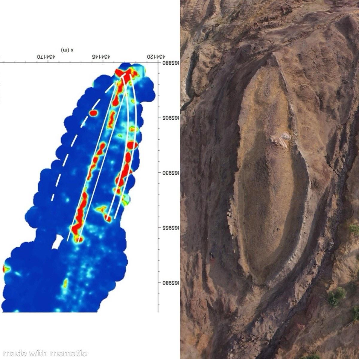
2019 GPR results (left) alongside aerial imagery of the formation (right), showing the linear and angular patterns that BakhtarRadar was deployed to re-examine.
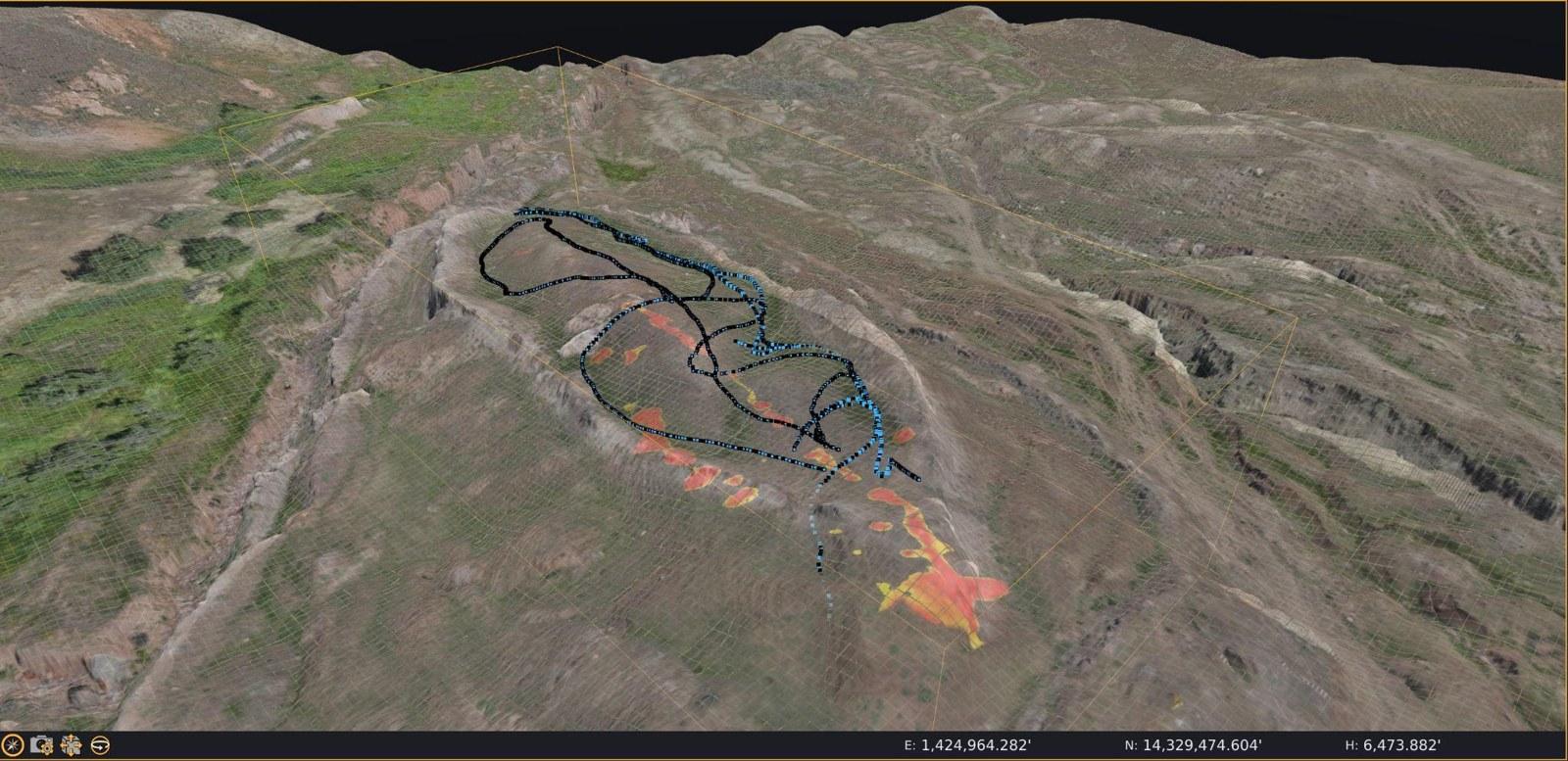
3-D terrain model of the Durupınar site with subsurface survey data overlaid from 2019 and 2026.
Noah’s Ark Scans is investigating the Durupınar site because its researchers believe it is a genuine candidate for Noah’s Ark. The purpose of the scientific program is to determine whether the physical evidence can withstand scrutiny and distinguish that interpretation from a purely natural geological explanation. Failure to identify a bedrock boundary in the data processed so far does not by itself prove bedrock is absent, and radar anomalies alone do not prove an archaeological origin. The full dataset must be processed, modeled and compared with the other geophysical information before firm conclusions are drawn.
Next: From Radar Targets to Physical Core Samples
A preliminary technical report is expected in the coming weeks. It will rank the strongest anomalies, refine the picture of the deeper geology, and pinpoint where targeted core drilling has the best chance of answering the central question — moving the project from remote sensing to physical evidence.
The 2026 program is being conducted under official Turkish authorization and is designed so that each method informs the next: BakhtarRadar, electrical resistivity tomography (ERT), and high-resolution surface mapping, soil and rock sampling, and targeted deep core drilling. No single method can settle the origin of the formation. The strength of the project is in comparing independent datasets and then testing the most important interpretations with physical samples. Dr. Bakhtar is working alongside Andrew Jones, Turkish Project Director Prof. Dr. Cenker Atila of Sivas Cumhuriyet University, and an international team of archaeologists, geologists and soil scientists.
“We are not trying to end this debate with a press release,” Jones said. “We believe this is Noah’s Ark, but the way to demonstrate that is to keep testing it. Dr. Bakhtar has brought an extraordinary level of experience and a very specialized radar technology to the site. The preliminary data are giving us strong targets. Now we need to finish the processing, choose the best core locations, and put physical samples in the hands of the scientists. That is where this becomes truly exciting.”
Processing of the BakhtarRadar dataset is continuing. The project team expects a preliminary report in the coming weeks, after which the results will be integrated with the existing geophysical surveys to prioritize targeted core-drilling locations and guide the next phase of the Durupınar investigation. In an effort to raise necessary funds to conduct core drilling, Noah’s Ark Scans has launched a fundraiser for core drilling efforts in partnership with GiveSendGo. To be part of this historic discovery and help fund the core drilling, visit the GiveSendGo campaign at: GiveSendGo.com/NoahsArk2026
The Noah’s Ark Project is a joint effort between Noah’s Ark Scans and Prof. Dr. Cenker Atila, Professor of Archaeology at Sivas Cumhuriyet University in Turkey, who serves as President of the project.
For More Information
Noah’s Ark Scans: Noahsarkscans.com
Media Inquiries: info@noahsarkscans.com
Photos accompanying this announcement are available at
https://www.globenewswire.com/NewsRoom/AttachmentNg/459d18b8-daec-499c-a2f1-d73087496774
https://www.globenewswire.com/NewsRoom/AttachmentNg/aeb2cd26-ff64-4be5-8b4c-5df78355b76f
https://www.globenewswire.com/NewsRoom/AttachmentNg/7df7c4a0-9ca5-4313-8c8f-7259c22fb308
https://www.globenewswire.com/NewsRoom/AttachmentNg/e1366dd8-f292-44e5-b3e7-7fe3f310b6eb

